Development/analysis environment

Tellus offers environments where you can perform detailed analysis and develop applications with rich lineups of specs.
Advantage of using Tellus development/analysis environment

No restriction on satellite data use
You can use all data on Tellus with Tellus environment, both free and priced data, so this is a perfect choice when you need a variety of data types.
Please note that some data types limit downloading only to Tellus environment and you still need to purchase priced data.
Downloadable data in your environment
- ASNARO-2 X-band SAR images Urban area dataset (STRIPMAP) (priced)
- ASTER GDEM ver.3
- AVNIR-2_1B1
- AW3D30
- GCOM-C/CHLA_8days
- GCOM-C/CHLA_NRT
- GCOM-C/SST_8days
- GCOM-C/SST_NRT
- GCOM-C/TSM_8days
- GCOM-C/TSM_NRT
- GOSAT-2/L2/SWIR CH4 column-averaged dry-air mole fraction(G2-02)
- GOSAT-2/L2/SWIR CO column-averaged dry-air mole fraction(G2-03)
- GOSAT-2/L2/SWIR CO2 column-averaged dry-air mole fraction(G2-01)
- GOSAT-2/L2/SWIR H2O column-averaged dry-air mole fraction(G2-04)
- GOSAT-2/L4A/global CO2 flux(G2-09)
- GOSAT-2/L4B/global CO2 distribution(G2-10)
- GOSAT/L2/SWIR CH4 column amount(G1-02)
- GOSAT/L2/SWIR CO2 column amount(G1-01)
- GOSAT/L2/SWIR H2O column amount(G1-03)
- GOSAT/L2/TIR CH4 vertical profile(Day side)(G1-05-1)
- GOSAT/L2/TIR CH4 vertical profile(Night side)(G1-05-2)
- GOSAT/L2/TIR CO2 vertical profile(Day side)(G1-04-1)
- GOSAT/L2/TIR CO2 vertical profile(Night side)(G1-04-2)
- GOSAT/L3/SWIR global CH4 distribution(G1-07)
- GOSAT/L3/SWIR global CO2 distribution(G1-06)
- GOSAT/L4A/global CH4 flux(G1-09)
- GOSAT/L4A/global CO2 flux(G1-08)
- GOSAT/L4B/global CH4 distribution(G1-11)
- GOSAT/L4B/global CO2 distribution(G1-10)
- HISUI *
- Maxar Technologies' satellites (priced)
- PALSAR_L1.1
- PALSAR_L2.2
- PALSAR-2_L2.2
* Need to apply for data use.
Downloadable data only in Tellus environment

Fast accessing
Data and development/analysis environment are in the Tellus cloud environment.
This makes downloading much faster than you do to your local or other cloud environment. This is perfect when you use huge satellite data.
- * Download speeds may vary depending on network congestion and device conditions.
Tellus analysis environment service
This is for when you need satellite data analysis with suitable aspects you need.
Analyse with GUI
“Tellus Satellite Data Master with QGIS” is ideal for:
- - Operating visually on the screen without using commands.
- - Visually checking data availability before obtaining it via API.
- - Using the familiar QGIS interface.
- - Utilizing Tellus's simple analysis tools through GUI.
Intuitive Operation with GUI
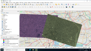
The operating system is Windows Server, allowing you to operate with the familiar Windows UI. The environment includes the pre-installed QGIS app, a globally used GIS (Geographic Information System), enabling you to analyze satellite data on the map.

Tellus Plugin
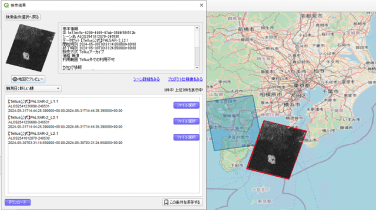
The QGIS app includes the Tellus plugin. This plugin allows you to search and download satellite data from Tellus, making it very convenient to obtain satellite data. After downloading the data, you can also mash it up with other data you have.

Utilize Tellus's Unique Analysis Tools
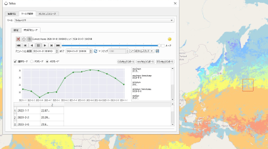
The Tellus plugin for the QGIS app also includes simple analysis tools. “Tellus-LFP” is a tool that can display GCOM-C data in a time series graph or visualize it with animations.
There are also other tools available, such as tools for automatically extracting differences between two periods of satellite data. Tools other than Tellus-LFP require a prior usage application (free purchase process), so please apply from the Tool Catalog.

- Tellus Satellite Data Master with QGIS (4GB)
-
- Price
- JPY29,700/month
- Virtual CPU
- 4Core
- Memory
- 4GB
- Storage
- 250GB SSD
- OS
- Windows Server
- Tellus Satellite Data Master with QGIS (8GB)
-
- Price
- JPY49,500/month
- Virtual CPU
- 6Core
- Memory
- 8GB
- Storage
- 500GB SSD
- OS
- Windows Server
- Tellus Satellite Data Master with QGIS (16GB)
-
- Price
- JPY93,500/month
- Virtual CPU
- 8Core
- Memory
- 16GB
- Storage
- 1TB SSD
- OS
- Windows Server
- System requirements:
- A device which can connect to Windows Server's Remote Desktop Services.
* All prices are tax included.
* Prices and services are subject to change without notice.
* This product is developed and sold exclusively by Tellus Inc. using the free GIS software QGIS, and QGIS.org is not responsible for the product.
Analyse with CUI
“Tellus Satellite Data Master” is ideal for:
- - Handling satellite data in a CUI environment with Python or other tools.
- - Analyzing satellite data using the Tellus APIs with various data and simple tools.
- - Reducing server costs.
Simple Server
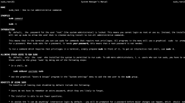
This is an analysis environment designed for those who do not need a pre-installed QGIS application. You can specify an open-source OS, such as Linux, and Tellus will install the OS and provide the server.
By integrating the Tellus APIs into your programs, you can analyze various satellite data from Tellus.

- Tellus Satellite Data Master (4GB)
-
- Price
- JPY17,600/month
- Virtual CPU
- 4Core
- Memory
- 4GB
- Storage
- 250GB SSD
- Tellus Satellite Data Master (8GB)
-
- Price
- JPY33,000/month
- Virtual CPU
- 6Core
- Memory
- 8GB
- Storage
- 500GB SSD
- Tellus Satellite Data Master (16GB)
-
- Price
- JPY55,000/month
- Virtual CPU
- 8Core
- Memory
- 16GB
- Storage
- 1TB SSD
- System requirements:
- A device which can connect to servers on the internet via SSH and other methods.
* All prices are tax included.
* Prices and services are subject to change without notice.
* We can also install the OS from an ISO image provided by you. Contact us for details.
- Notes:
-
- - Monthly fees are charged for the period from the 1st to the last day of each month. Even if your contract starts in the middle of the month, you still need to pay for the entire month.
- - Only credit card payments are accepted.
- - Payments are made in Japanese Yen(JPY).
- - Consumption taxes will be charged based on the tax rate in Japan.
- - Please refer to “Payment method for satellite data master series” for payment details.
- - Please refer to “I would like to cancel my analysis environment” for canceling a contract.
- - Please carefully read and agree to the terms of service.
- - If you are a minor, you must have parental consent.
- - The initial language setting for Tellus Satellite Data Master with QGIS on Windows is Japanese.
- - For any other questions, please refer to our FAQs.
Tellus development/environment service
This is for when you develop services or applications with satellite data. You can structure your own environment.
You can add GPU and object storage as options for high-load analysis like model development with machine learning.
Environments with a variety of specs are available
For applications or questions, please click on “Inquiry” to proceed to the inquiry form.
We will inform you about the contracting procedure.